The always Greek DHAVLOS |
|
The name of Dhavlos is Greek and during its long history the village was never inhabited by Turkish Cypriots. Before the 1974 Turkish invasion, the village was exclusively inhabited by Greek Cypriots who lived peacefully there and they never had a conflict with Turkish Cypriots from other neighboring villages. How the name ''Dhavlos'' was given to the village. There are many versions regarding the way Dhavlos was given its name. The most prevalent one, is that given by folklore scientist Nearchos Clerides and other researchers, a summary of which is given below. This version is also sypported by the fact that the village of Dhavlos is present on all maps of Cyprus published during the 16th and 17th centuries. There is also evidence that the Christian residents of Dhavlos who were forcibly expelled by the Turks in 1975 settled in the village during the 17th century. At that time the village was abandoned, most probably due to pirate raids. The word "dhavlos" in the Greek language means half-burned firewood, firewood in general but also a place covered with thick forest. The village was first inhabited BC. At that time the woods were sacred and the Apollo-Hylates worship was common in Cyprus. In the Phokis district in mainland Greece there was a small town called Dhavlis which was set on fire by Xerxis during his descent to Athens. It is certain that the village of Dhavlos on the northern side of the Kantara mountains was given that name because it was built within a thick forest ΒC most probably by Greek settlers. References: Nearchos
Clerides. Villages and Towns of Cyprus (In Greek) Nicosia 1961 (p. 74) A summary of narratives of elderly residents from Dhavlos on how the village was inhabited again in the recent years. The residents of Dhavlos came from the village of Tzionia which was on the southern side of Kantara mountains close to the Turkish Cypriot village of Ovgoros and Kantara Castle. When the village of Ovgoros was built, the residents of that village used to attack the Christian residents of the neighboring village of Tzionia. As a result of these attacks, the residents of Tzionia who were shepherds and farmers took their families and their flocks and headed towards the Mesaoria plain where they settled in other Greek Cypriot villages so that they could avoid the attacks of the Turkish Cypriots. Two families, however, instead of following the rest towards the Mesaoria plain passed the northern side of the Kantara mountain and reached the ruined and abandoned, most possibly due to pirate raids, old village of Dhavlos and settled there. It is estimated that this settling took place during the middle of the 17th century. The first houses were built in what is today the southern end of the village close to the Church of Ayios Georghios since the ''Vrysi" (in Greek means spring) was a short distance from where the residents used to get drinking water. The Church of Ayios Georghios as well as the nearby chapel of Ayia Katerina were abandoned and ruined. The Church of Ayios Georghios was repaired at the initial stages of habitation of the village to provide for the religious needs of the residents. The closeby chapel of Ayia Katerina was preserved as a place of worship and was eventually repaired in the 1960 decade. The village started to grow with the settling or marriage of new residents who arrived from other villages and who were welcome to the village, since there was plenty of land in which to settle. From the ruins which the first inhabitants of the village found, it was evident that at that place there were Churches and Monastery Dependeries. The first two families who settled in the village because of respect or perhaps engrossment avoided to cultivate land which belonged to the Churches and the Monastery Dependeries. As a result of this, the land belonging to their present day descendants is located in a north - south trending strip of land in the centre of the village. The families that came later to stay in the village settled around the strip of land already occupied by the village's first inhabitants. This way the village took its present shape. In an area in the centre of the village the soil is full of stones and is called ''petrera'' (in Greek this means ''rocky place''). It is presumed that these stones came from the foundations of older houses, which at the time were made of stones and lime or mud mortar. Between Dhavlos and Kantara Castle is the monastery of Ayios Nikolaos. Monks used to live there, until the years of Ottoman rule in Cyprus. The last monks were killed by the Turks during the Ottoman rule and the monastery remains abandoned ever since. Map evidence support
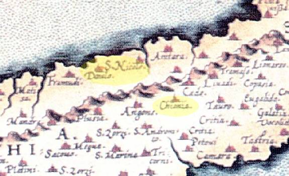
The village Tzionia does not exist on the present day maps. In all the maps published during the 16th and 17th centuries Tzionia, Ayios Nikolaos Monastery and Dhavlos exist. At the left a detail of a map published by Abraham Ortelius in Antwerp in 1573, (two years after the Ottomans occupied Cyprus), is shown. The village Dhavlos (Davlo), the monastery of Ayios Nikolaos (St. Nicola) and the village of Tzionia (Chionia) are shown with a yellow highlight. The Turkish Cypriot village of Ovgoros is post 17th century and is not shown on that map.
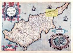
This is the map of Abraham Ortelius published in 1573 in Antwerp. The yellow highlight shows the enlarged detail given above.
|